
Kohm Yah-mah-nee Visitor Center
21820 Lassen Peak Hwy,
Mineral, CA 96063
Lassen Volcanic National Park is located in northeastern California, within the southern section of the Cascade Range. It is about 130 miles (210 km) northeast of Sacramento and approximately 50 miles (80 km) east of Redding, California. The park covers more than 106,000 acres and is known for its unique volcanic landscape, geothermal features, and rugged mountain scenery. Whether you choose to camp within the park, stay at a nearby community or call Sacramento your basecamp, you can travel to Bumpass Hell and back in one day.
Lassen Volcanic Updates (Current as of Sept 24, 2024):
Juniper Lake Road remains closed to vehicle traffic after the 2021 Dixie Fire. There is no current re-opening date. The road is open to bicycle and pedestrian traffic.
Warner Valley Road remains closed at the trailhead parking area due to the 2021 Dixie Fire. The road will close at the park boundary once winter snow sets in.
Timeline:
10/04/2021: Portions of the park unaffected by the Dixie Fire re-open. This includes two portions of the highway: 8 miles from the Southwest Entrance to Lassen Peak parking area and 1 mile from the Northwest Entrance to Loomis Plaza and 8 trails.
Lassen Resilience Program: Lassen Association and Lassen Park Foundation, in partnership with Lassen Volcanic National Park, have created the Lassen Resilience campaign to showcase the park’s resilience and bolster recovery efforts following the 2021 Dixie Fire.https://www.nps.gov/lavo/planyourvisit/conditions.htm (accessed September 24, 2024)
-
Is the scenic drive in Lassen Volcanic National Park currently open?
-
The Season for Lassen Volcanic National Park was off to a good start with the Scenic Drive opening 06/20/2024. Due to a fire evacuation in July, 2024, the park closed. Some roads in the park were opened on August 17, 2024. All roads opened in Lassen Volcanic by August 27, 2024. Travelers should anticipate closures as early as October with expected snowfall for winter (2024/2025). For up to date information refer to the following sources: Lassen Volcanic National Park NPS, Spring Clearing on NPS (Snow Plowing and Road Openings), Caltrans Quick Map and Lassen Volcanic NP on X.
Naturalist’s Perspective
I find it easier to think of parks in terms of regions rather than state boundaries. Lassen is part of the Volcanic Legacy Scenic Byway, forming a “sisterhood of traveling ashes” with other volcanic parks. Pardon the pun—I’m letting the theme of this blog run a little wild, but I assure you, I won’t let it all erupt too soon!
As a master naturalist, I tend to go heavy handed on listing endemic species, identifying habitats and sequestering the expertise of rangers through Ranger-Led programs. As responsible adventurers we can enjoy an abundance of recreation in the park as a way to preserve the ecosystems and species that are protected. And on that note, I focus on idea boards and ways to see more of the public lands across the globe.

About Me
Hey there! I’m Jenn from jenonthetrail.com, and I’m here to share my love for America’s incredible national parks and public lands. I’ve explored 62 of the 63 national parks in the U.S., and many of them I’ve visited more than once. People often ask me, “What park is your favorite park?” as if picking just one could answer this multi-complex question. But honestly, I believe everyone should try to visit as many as possible! Let’s discover more of America’s natural heirloom, The National Park System.
5 Fast Facts about Lassen Volcanic National Park
Home to All Four Types of Volcanoes: Lassen Volcanic National Park contains all four types of volcanoes—shield, composite, cinder cone, and plug dome—making it a geological wonder.
Last Eruption in 1915: Lassen Peak erupted between 1914 and 1917, with the most dramatic event occurring in May 1915.
Among the least visited Parks: With around 500,000 visitors a year, Lassen Volcanic is among the least visited parks.
Part of the Volcanic Legacy Scenic Byway: Lassen Volcanic is a key stop along this 500-mile route through Northern California and Oregon, showcasing some of the region’s most stunning volcanic landscapes.
Diverse Ecosystems: Despite being a volcanic hotspot, the park is rich in biodiversity, with forests, alpine meadows, and more than 200 species of birds and mammals calling it home.
Calling all Geology Enthusiasts
Leave your inner “Bumpass” behind and head north from Sacramento, California, to witness the Yellowstone of the Cascades. Lassen Volcanic National Park, with its dramatic volcanic landscape, often feels more connected to regions like Oregon, Washington, Hawaii, and Yellowstone than to California itself.
Q: What are the hydrothermal features of Lassen Volcanic National Park?
- A: Lassen Volcanic National Park is known for its incredible hydrothermal features, including:
- Bumpass Hell: The park’s largest geothermal area, with mud pots, fumaroles, and boiling springs.
- Sulphur Works: A roadside hydrothermal area that gives a close-up look at fumaroles and bubbling mud pots.
- Boiling Springs Lake: A 125-degree hot lake located in Warner Valley, accessible via a moderate 3-mile round-trip hike.
- These features are remnants of the park’s volcanic activity and are similar to those found in Yellowstone. Stay on designated paths for safety, as ground temperatures can be dangerously high in some areas.
Scenic in Lassen Volcanic Park
The most scenic view is often considered to be Lassen Peak and the surrounding landscape from its summit. From the top, visitors can see a panoramic view of alpine forests, volcanic domes, distant mountains, and the surrounding wilderness. Another highly scenic area is Lake Helen, with its turquoise waters framed by volcanic peaks.
Aes·thet·ic
Picture towering volcanic peaks framed by lush green trees in summer, and in winter, a blanket of snow stretches as far as the eye can see. The park’s stunning beauty lies in its dynamic geothermal features, serene alpine lakes, and the striking contrast between dense forests and rugged volcanic landscapes. The blend of vibrant vegetation, steaming mud pots, and sharp volcanic summits gives the park an almost otherworldly allure, especially at sunset when the golden light ignites the land in a breathtaking display of color.
Historic at Lassen Volcanic Park
The most significant eruption of Lassen Peak occurred between 1914 and 1917, with the largest explosion on May 22, 1915. It was the last eruption in the Cascade Range before Mount St. Helens erupted in 1980.
What’s in A Name?
To Bumpass Hell and Back
Bumpass Hell is named after Kendall Vanhook Bumpass, who discovered the area in the 1860s. Unfortunately, Bumpass fell into a boiling hot spring, severely injuring his leg, leading to the area being named in his honor. This geothermal basin is known for its vibrant hydrothermal features, including boiling springs, fumaroles, and colorful, mineral-rich waters.
Phenomenon
Lassen Volcanic National Park is the only place in the world where you can find all four types of volcanic activity in one area: plug dome, shield, cinder cone, and stratovolcano. This geological diversity makes it stand out compared to other parks in the Pacific Northwest, which may have only one type of volcanic feature.
The Wow Factor!
Mount Lassen: The park’s namesake volcano offers breathtaking views, especially from the summit hike, where you can see the surrounding landscape.
For Park’s Sake
International Designation
Biosphere, UNESCO, and RAMSAR
No UNESCO World Heritage designations, Ramsar (wetland of international importance), or Biosphere Reserve designations have been named to Lassen Volcanic National Park. However, it is known for its volcanic and geothermal significance, particularly being part of the Cascade Range, but it has not received these specific international recognition.
Dark Sky Park
In 2023, Lassen Volcanic National Park was officially designated as a Dark Sky Park by the International Dark-Sky Association (IDA). This designation acknowledges the park’s commitment to preserving its dark night skies, making it an ideal location for stargazing, particularly due to its remote location and low light pollution. The designation also highlights the park’s efforts to educate the public about the importance of dark skies and the impact of light pollution on ecosystems. It’s a newbie on the list but visitors to the park have been in on this secret night sky treat for generations.
Cultural and Historic Preservation
Indigenous Heritage: Yana/Yahi, Astsugewi, and Mountain Maidu
Yana: The Yana occupied lands southeast of Lassen, along the eastern edges of the Sacramento Valley and surrounding foothills. This tribe included the more well-known Yahi subgroup, to which Ishi, “the last Yahi,” belonged.
Atsugewi: This tribe lived to the north and northeast of Lassen, in the Pit River Basin, and were primarily hunters, gatherers, and fishers.
Maidu (Mountain Maidu): The Maidu people lived to the west and southwest of Lassen, in the valleys and mountains around the Feather River region. They also relied on hunting, gathering, and fishing, and had close ties to the volcanic landscape, which was spiritually significant to them.
The 1915 eruption of Lassen Peak was significant, it did not lead to large-scale displacement of Indigenous peoples in the region. While the eruption itself was localized, and while it affected the surrounding areas through ashfall and mudflows, the main areas inhabited by the tribes (like the Pit River region for the Atsugewi) were outside the most immediate danger zone.
There are no widely documented large-scale forced relocations specifically due to Lassen’s creation, the establishment of the park imposed restrictions on the traditional practices of the local tribes. Indigenous peoples were often prohibited from hunting, fishing, gathering plants, and conducting cultural activities within the newly designated park boundaries.
Today, many descendants of the Atsugewi, Maidu, and Yana live on nearby reservations or rancherias in Northern California. Some notable Indigenous communities include:
Pit River Tribe: Descendants of the Atsugewi are part of the Pit River Tribe, which has several small reservations in the region.
Maidu: Descendants of the Maidu people are part of various federally recognized and unrecognized tribes, including the Susanville Indian Rancheria and Enterprise Rancheria.
Yana/Yahi: The Yana tribe, particularly the Yahi subgroup, was devastated by settler violence and disease. Ishi, who is often called the “last Yahi,” was the final known survivor of this group, and he passed away in 1916. Today, descendants of related Yana peoples may still live in the region.
Fees, Timed- Entry and Lotteries for Lassen Volcanic National Park
Permits and Fees: Single Park Annual Pass or America the Beautiful Pass
Private Vehicle:
$30 for a 7-day pass (April 15-November 30).
$10 Valid for up to 7 consecutive days at Lassen Volcanic National Park between December 1 and April 15. Payable in-person at park entrances. Self-registration when not staffed.
Motorcycle:
$25 for a 7-day pass. (high season)
$10 for December 1 through April 15.
Individual (on foot or bicycle): $15 for a 7-day pass.
Single Park (Lassen Volcanic) Annual Pass: $55 for a year of unlimited visits.
All Parks Annual Pass: Visiting more than two parks this year? Purchase an annual interagency pass (America the Beautiful Pass).
Pass:
Timed Entry, Lotteries and Reservations:
While no timed entry has been implemented at Lassen National Park, it’s crucial for visitors to stay informed about potential closures due to fall fires and heavy snowfall. Before your visit, make sure to monitor the following resources:
California Highway Conditions: Caltrans provides updates on road openings and closures due to snow plowing.
California Forest Service Fire Updates: Check the U.S. Forest Service for information on current burn conditions.
One cannot escape the Lesson in Logistics of Lassen Volcanic National Park; being aware of this is essential for a smooth visit!
Bucket List
Climb Lassen Peak
- Drive and explore several of the parks along the Volcanic Legacy Scenic Byway
Geology
Volcanic activity shown is 5 different sites along the byway.
Volcanic peaks to lava beds.
Cultural and Historic
Big Painted Cave and Symbol Bridge: These caves, part of the Lava Beds National Monument, feature Native American pictographs
Scenic
The waterfall region with the spectacular McArthur-Burney Falls Memorial State Park.
While not a lava bed itself, the park lies in a volcanic region, with the falls fed by underground springs coming from ancient volcanic rocks.
The picturesque Mount Shasta and Crater Lake of Crater Lake National Park.
Wildlife
The Lower Klamath (on the Volcanic Legacy Byway) is one of the two white pelican nesting colonies in California.

Weather
Summer: Warm daytime temperatures and cool evening temperatures. Sunny days dominate with occasional thunderstorms. Expect a 5° temperature decrease for every 1,000 foot increase in elevation. View the weather forecast for each area prior to your visit. Manzanita Lake Area (5,800 ft / 1,767 m) average summer high / low: 82° / 39°F ( 28° / 4°C).
Fall: Cool, with temperatures dropping into the 40s-60s°F.
Winter: The park receives up to 30 feet of snowfall in the winter/spring snow season (approximately November through May). Sunny skies are common between short (1 to 3 day) snow storms. Winter/spring temperatures in the Southwest Area (6,700 feet elevation) range from highs of 50°F to 61°F to lows of 13°F to 23°F. Temperatures in the Manzanita Lake Area (5,800 feet elevation) run about 5° warmer. Expect a 5° temperature decrease for every 1,000 foot increase in elevation.
Spring: Lassen Volcanic National Park experiences a mix of weather conditions, largely due to its high elevation. Snow often lingers into May and even June, especially at higher elevations, so many areas of the park, including roads and trails, may still be covered. Here’s a breakdown of typical spring weather in Lassen:
- March-April: Cold with significant snow still on the ground. Daytime highs are usually in the 40s°F (4-9°C), and nighttime lows can dip into the 20s°F (-6 to -1°C). Snowshoeing and cross-country skiing are popular activities.
- May: Snow begins to melt in lower elevations, with daytime highs in the 50s°F (10-15°C) and lows in the 30s°F (0-4°C). However, snow may still cover higher-elevation trails and roads. Some roads, like the scenic Lassen Park Road, often remain closed until late May or early June, depending on snow levels.
Spring weather in Lassen is unpredictable, so it’s best to check conditions before visiting and come prepared for snow and cold temperatures.
Closures
Few parks have as much riding on the fact that their plans to visit said national park may end in a denial to enter or multiple trail closures as Lassen Volcanic National Park
Seasonal Closures:
The park highway is closed to through traffic due to snow approximately November through May. During heavy winters, the highway may close to
through traffic as early as late-October and open as late as mid-July. Other park roads to Juniper Lake, Butte Lake, and Warner Valley Areas are also closed in winter.
Two routes around the park connect the Manzanita Lake and Southwest Areas. Travel time is approximately 90 minutes to 2 hours in
normal winter driving conditions. Caltrans
Wildfire Closures:
In the event of wildfires, road closures can affect entrance into the park. Historic closures were in place in 2021 due to the Dixie fires.
For both Seasonal and Wildfire Closures, refer to apps and websites for up to date coverage.
California Highway Conditions: Caltrans provides updates on road openings and closures due to snow plowing.
California Forest Service Fire Updates: Check the U.S. Forest Service for information on current burn conditions.
Regional Orientation

Getting To Lassen Volcanic National Park
I’ve visited Lassen Volcanic National Park twice, each time with a half-day itinerary. Traveling from Sacramento, California, makes for a pleasant visit, allowing ample time for hikes and exploration of the park’s southern area.
By contrast, coming from Northern California destinations such as Redwoods or Reno Nevada can turn the visit to the park into a long day (of driving). This routes leaves little more than an hour to explore trails but offers one specular scenic drive from the northern entrance to the southern entrance.
Here are the closest airports to Lassen Volcanic National Park, along with their approximate distance, drive time, and airlines that typically serve them:
Redding Municipal Airport (RDD)
- Distance to Lassen: ~50 miles
- Drive time: ~1 hour 15 minutes
- Airlines: United Express (via SkyWest Airlines)
- Details: Redding is the closest commercial airport to Lassen, with limited service, primarily connecting to hubs like San Francisco (SFO).
Chico Municipal Airport (CIC)
- Distance to Lassen: ~75 miles
- Drive time: ~1 hour 45 minutes
- Airlines: Boutique Air (service to San Francisco and Los Angeles) *I’ve flown on Boutique air from Carlsbad, NM to Dallas, TX. Their service and attention to detail was top-notch. I highly recommend using Boutique Air when an opportunity arises in your travel.
- Details: A small regional airport with limited flights, but sometimes an option for visitors.
Reno-Tahoe International Airport (RNO)
- Distance to Lassen: ~130 miles
- Drive time: ~2 hours 30 minutes
- Airlines:
- Alaska Airlines
- American Airlines
- Delta Airlines
- Southwest Airlines
- United Airlines
- JetBlue Airways
- Details: Reno offers a wider range of flight options and is a popular airport for travelers heading to Lassen, especially if combined with a visit to the Lake Tahoe area.
Sacramento International Airport (SMF)
- Distance to Lassen: ~150 miles
- Drive time: ~3 hours
- Airlines:
- Alaska Airlines
- American Airlines
- Delta Airlines
- Southwest Airlines
- United Airlines
- Spirit Airlines
- JetBlue Airways
- Details: Sacramento is a major airport serving numerous domestic destinations, with frequent flights and rental car options.
San Francisco International Airport (SFO)
- Distance to Lassen: ~220 miles
- Drive time: ~4.5-5 hours
- Airlines:
- Major carriers such as Alaska, American, Delta, United, Southwest, JetBlue, and more.
- Details: SFO is a major hub with flights from around the world, but it’s a longer drive to the park compared to the other airports.
For the closest, Redding and Chico are ideal for a short drive, while Reno and Sacramento offer more flight options but slightly longer drives.
Train Services: While there isn’t a direct train service to Lassen Volcanic National Park, there are options for getting there by bus or shuttle.
Shuttle Services: Some local tour companies may offer shuttles to the park, especially during the peak season. It’s worth checking with local visitor centers or tour operators in nearby towns like Redding or Chester.
Bus Services: Greyhound and other regional bus services can get you close, but you might need to arrange local transportation (like a taxi or rideshare) to the park from the nearest bus station.
Rental Cars: Renting a car is a popular option since it allows more flexibility to explore the park and surrounding areas.
This timeline will illustrate that the area now known as Lassen Volcanic had local popularity and was a draw for adventurers in the 19th century. Even the same day as the eruption in the area, B.F. Loomis photographed a “hot” rock in the area but returned home prior to the ash blast at 4PM. First-hand accounts of the eruption in 1914 are available to us because of individuals who recognized the importance of studying the geological changes along the Pacific Rim of Fire.
Post-Glacial Activity to Present: Lassen Volcanic Timeline
Post-Glacial Period (~12,000 years ago)
- End of the Ice Age: Lassen Peak forms after the last major ice age, creating the volcano atop the collapsed Mount Tehama.
Indigenous Presence (Pre-European Contact)
- Maidu People: Indigenous Maidu people inhabit the Lassen area for thousands of years, understanding the geothermal and volcanic features of the land.
Early European Exploration (Mid-1800s)
- 1850s: Early settlers begin mapping the Lassen area, bringing it to the attention of scientists and explorers.
Kendall Vanhook Bumpass (1864)
- 1864: Bumpass falls into a boiling mud pot, bringing national attention to what is now called “Bumpass Hell.”
Helen Tanner Brodt (1864)
- 1864: Helen Tanner Brodt becomes the first recorded white woman to summit Lassen Peak.
Late 1800s–Early 1900s
- Mount Lassen’s Popularity Grows: The unique volcanic and geothermal features of Lassen draw increasing numbers of explorers, scientists, and tourists.
The Lassen Eruption Series (1914-1921)
Early Signs of Volcanic Activity (1914)
- May 30, 1914: Lassen Peak experiences its first significant steam explosion, beginning a series of intermittent eruptions over the next year.
- 1914-1915: Eruptions continue, increasing in frequency and intensity, building a new lava dome at the summit.
May 21-22, 1915: The Days Leading to the Great Blast
- May 14, 1915: A significant eruption creates a lava dome at Lassen’s summit, sending hot lava down the northeast slope. This marks a pivotal moment in the volcano’s eruptive phase.
May 21, 1915: B.F. Loomis’ Morning Photography Session
- Morning of May 21, 1915: B.F. Loomis, a local amateur photographer, arrives near Lassen Peak to document the aftermath of the May 14 eruption.
- He photographs the “Hot Rock,” a large, steaming boulder that had been ejected during the eruption and had landed in the Devastated Area. This rock becomes a symbol of the volcanic power at Lassen.
- Loomis Runs Out of Film: After capturing these images, Loomis leaves the area because he has no more film in his camera, returning home unaware of the approaching disaster.
May 22, 1915: The Catastrophic Eruption
- Afternoon of May 22, 1915 (4 PM): After Loomis has left the scene, Lassen Peak erupts violently in its most powerful explosion.
- Pyroclastic Flow: A massive pyroclastic flow, a mixture of superheated gases, ash, and rock, races down the northeastern side of the volcano, devastating everything in its path.
- Lahar (Mudflow): The eruption melts snow and ice on Lassen’s slopes, creating a large lahar (mudflow) that surges down the mountain, obliterating trees and filling the valleys.
- Ash Plume: The eruption sends an ash plume 30,000 feet into the sky, visible from over 150 miles away. Ashfall is reported in towns as far as Nevada.
- Loomis Unharmed: B.F. Loomis is safely away from the scene at the time of the eruption, having left earlier in the day after running out of film. He was fortunate to avoid the massive blast, which occurred just hours after his departure.
Aftermath of the 1915 Eruption
- Photographs as Historical Record: Loomis’ earlier photographs, especially of the Hot Rock, become vital records of the eruption. His images are some of the only visual documentation of the volcano’s activity and are widely circulated.
- The Aftermath: Following the eruption, Loomis continues to document the changes in the landscape and raises awareness about the need to protect Lassen and its unique geothermal features.
- 1915-1917: Smaller eruptions follow, but none match the intensity of the May 22 blast. Scientists flock to the area, making it a center for volcanic research.
- B.F. Loomis’ Contribution: Loomis becomes a leading advocate for the preservation of Lassen. His photographs and documentation help convince Congress to establish the area as a national park.
Mid-20th Century (1930s–1950s)
- Increased Tourism and Conservation: During the Great Depression, the Civilian Conservation Corps (CCC) helps develop park infrastructure, including roads, trails, and facilities, making the park more accessible to visitors.
Late 20th Century (1960s–1990s)
- Conservation Efforts: The park focuses on maintaining natural ecosystems and preserving the geothermal features and volcanic activity while supporting growing visitor numbers.
21st Century
- Continued Volcanic Monitoring: Lassen Volcanic remains active, though no major eruptions have occurred since 1917. The U.S. Geological Survey (USGS) monitors the region closely for signs of future volcanic activity.
- Modern Park Visitation: The park continues to attract hikers, naturalists, and scientists alike, offering a combination of natural beauty and geological intrigue.
Present
- Conservation & Education: Lassen Volcanic National Park today is a significant site for studying active volcanic processes. It plays a crucial role in educating the public about volcanic hazards and geothermal features while continuing to draw visitors fascinated by its history of mishaps and close-calls.


The Visitor Experience
Elevation of the Park
Lassen Volcanic National Park has an elevation range from approximately 5,350 feet (1,630 meters) at the entrance to about 10,457 feet (3,187 meters) at the summit of Lassen Peak. The variation in elevation contributes to the park’s diverse ecosystems and stunning landscapes.
Acclimatizing to the high elevations of Lassen Volcanic National Park (5,350 to 10,457 feet) can be challenging for some visitors. Here are some helpful tips to prevent altitude sickness and make your visit more enjoyable:
Take it Slow
- Ascend gradually: If possible, spend a night at a moderate elevation (around 5,000–7,000 feet) before ascending higher into the park.
- Start with easier hikes: On your first day, choose less strenuous activities to allow your body to adjust to the altitude.
Stay Hydrated
- Drink plenty of water: Higher elevations can cause dehydration more quickly. Drink more water than usual, especially when hiking.
- Avoid alcohol and caffeine: Both can contribute to dehydration and exacerbate altitude sickness.
Eat Light, High-Carb Meals
- Carbohydrate-rich foods can help maintain energy levels and are easier to digest at higher elevations.
- Eat smaller, more frequent meals to prevent bloating, which can happen at high altitude.
Monitor Your Body’s Response
- Watch for symptoms of altitude sickness: Headaches, nausea, shortness of breath, and dizziness are common signs. If symptoms persist or worsen, descend to a lower altitude.
- Rest frequently: Give yourself time to adjust by taking breaks, especially during physical activity.
Consider Medication
- If you’re prone to altitude sickness, consult your doctor about taking acetazolamide (Diamox), a medication that can help with acclimatization. This medication is a diuretic which may lead to dehydration through its mechanism of action of the removal of water. I take acetazolamide for an intermittent condition with my eye and the oral medication comes with a bothersome side effect. There is a noticeable tingling sensation in lips and fingers and this side effect happens when I am in Florida as well as Colorado, therefore it is independent from altitude.
Acclimatize Before Hiking Lassen Peak
- Lassen Peak reaches over 10,000 feet, so it’s best to spend a day or two at lower elevations in the park before attempting this hike.
Navigating the Park
Roadways
The scenic drive through Lassen Volcanic National Park from the north entrance to the southern entrance is known as the Lassen Volcanic National Park Scenic Byway. More on the scenic drive in the TOURING section.
Main Roadways
- Lassen Volcanic National Park Highway (CA-89): This scenic highway runs through the heart of the park, connecting the northern and southern entrances. It’s about 30 miles (48 km) long and provides access to most of the park’s highlights and trailheads.
- Summit Lake: Located roughly halfway along the highway, making it a great stop for both camping and day hiking.
- Emerald Lake and Lake Helen: Picturesque lakes near Lassen Peak, offering quick photo opportunities or picnic spots.
- Sulphur Works: Just a few miles from the south entrance, this geothermal area is easily accessible for a quick stop.
- Access: The road is paved and generally in good condition, but it’s steep and winding, especially at higher elevations near Lassen Peak. Driving can be slow-going in some areas, so plan extra time.
- Seasonal Closures: The road is usually closed by snow from mid-October to late June or early July. Be sure to check road conditions before your visit if you’re traveling in spring or fall.
Trailhead Accessibility
- Parking lots at major trailheads: Most trailheads have designated parking areas, but these can fill up quickly during peak times (summer weekends and holidays).
- Lassen Peak Trailhead: Located just off the highway, near the highest point on the road (~8,500 feet), it has a spacious parking lot, but it fills up early.
- Bumpass Hell Trailhead: This is one of the most popular spots in the park. The parking lot is medium-sized but can be busy due to the popularity of this geothermal area hike.
- Manzanita Lake: Easily accessible from the northern entrance, with ample parking and great for shorter hikes or kayaking.
- Accessibility to lesser-known trails: Trails like Cinder Cone (in the northeast corner of the park) and Butte Lake require travel on gravel roads but are well-marked. These areas are quieter but offer incredible hikes.
Tips for Easy Navigation
- Start early: If you’re visiting during peak season, plan to arrive at trailheads before 9 AM to secure parking.
- Bring a map: Cell service is limited, so having a paper map or offline GPS is recommended.
- Shuttle service: There is no regular shuttle service within Lassen, so you’ll need to rely on your own vehicle to reach most trailheads.
- Road safety: Watch for wildlife, steep drops, and sharp curves. Drive cautiously, especially on the ascent to Lassen Peak.
- Restrooms and services: These are limited, with some at visitor centers, trailheads, and campgrounds, so plan accordingly.
Key Stops Along the Highway
- Kohm Yah-mah-nee Visitor Center (South Entrance): A great place to start, with exhibits, maps, and a café.
- Loomis Museum (North Entrance): Located near Manzanita Lake, it provides historical context on the park’s volcanic activity.
Accessibility
Lassen Volcanic National Park has several accessible features to accommodate visitors with mobility considerations, including some trails, overlooks, restrooms, and facilities. Here’s a breakdown of the accessible points of interest in the park:
Visitor Centers
- Kohm Yah-mah-nee Visitor Center (South Entrance): Fully accessible, with wheelchair ramps, accessible restrooms, exhibits, and a film about the park with captions and audio descriptions.
- Manzanita Lake Visitor Center (North Entrance): Offers accessible parking, restrooms, and services.
Trails and Features (check trail conditions prior to arrival)
- Devastated Area Interpretive Trail
- Distance: 0.5-mile paved loop.
- Details: A flat, wheelchair-accessible trail with interpretive signs, offering views of the park’s volcanic features and explaining the 1915 eruption of Lassen Peak.
- Sulphur Works
- Details: Accessible geothermal area right off the road with a paved overlook for viewing boiling mud pots and fumaroles.
- Manzanita Lake Trail
- Details: The first part of this 1.8-mile trail is relatively flat and accessible, providing scenic views of Manzanita Lake and Lassen Peak.
- Loomis Museum
- Located near Manzanita Lake, this museum is wheelchair accessible, with accessible restrooms and exhibits.
Accessible Campgrounds
- Manzanita Lake Campground: Offers accessible campsites with accessible restrooms.
- Summit Lake North Campground: Has a few accessible campsites, although the terrain may be slightly uneven.
Restrooms
Accessible restrooms are available at visitor centers, picnic areas, and some trailheads, including the Devastated Area, Kohm Yah-mah-nee Visitor Center, and Sulphur Works.
While many areas of the park are accessible, some parts of Lassen, such as high-elevation trails and rugged volcanic terrain, are challenging for visitors with mobility considerations. It’s always a good idea to check with park rangers for real-time accessibility conditions and any additional accommodations that may be available during your visit.
Park Shuttle
Lassen Volcanic National Park does not currently have a shuttle system in place. Visitors need to use their own vehicles to explore the park or drive the scenic byway between entrances. Parking is available at major trailheads and points of interest, but during peak season, parking can fill up quickly, especially at popular spots like Bumpass Hell and Lassen Peak.
If you’re planning a visit during the busier months, it’s best to arrive early to secure parking at the areas you’d like to explore.
Personal Vehicle
Driving your own car is by far the most popular choice for visitors to Lassen Volcanic National Park.
Complete control over schedule: You can explore at your own pace and visit less crowded areas of the park.
Privacy and comfort: Personal vehicles offer comfort, convenience, and the ability to store gear, water and other necessities. Be bear aware: Snack storage can attract bears.
Accessibility: Ideal for families, those with mobility limitations, or travelers with specific destinations in mind.
Bicycle
Lassen Volcanic National Park allows bicycles on the park roads but does not have dedicated bicycle trails. Cycling on the park’s hiking trails or in the wilderness is not permitted. However, the Lassen Volcanic National Park Scenic Bywayoffers a beautiful and challenging ride for cyclists, with steep climbs and descents, including spectacular views of the park’s volcanic landscape.
Ideal Starting Point for Cyclists:
A great starting point would be the Manzanita Lake area near the north entrance. From there, you can embark on the park’s scenic byway and make your way south. This route includes a challenging climb to the highest point at 8,512 feet near the Lassen Peak trailhead.
Since the park roads include significant elevation changes and can be quite strenuous, the ride is best suited for experienced cyclists who are comfortable with steep terrain. If you’re riding during peak season, be cautious of vehicle traffic, and always carry plenty of water as services are limited.
For a more leisurely ride, you could cycle around the Manzanita Lake area or take in the scenic views near Butte Lake and Summit Lake.
1-Day Itinerary for Lassen Volcanic National Park to go to Bumpass Hell and Back
Here’s a great one-day itinerary for exploring Lassen Volcanic National Park:
Morning: Bumpass Hell Trail
Bumpass Hell And Back
- Start early with the popular Bumpass Hell trail, a 3-mile round-trip hike leading to geothermal features, including boiling mud pots and steaming fumaroles. The trail offers fantastic views and a firsthand experience of the park’s volcanic activity. It’s one of the most iconic hikes in the park, so arriving early helps avoid crowds and enjoy cooler temperatures.
Midday: Lassen Peak or Sulphur Works
- Option 1: Lassen Peak: If you’re an avid hiker, consider tackling the Lassen Peak Trail, a strenuous 5-mile round-trip hike. You’ll ascend about 2,000 feet, but the panoramic views from the summit make the effort worthwhile. AllTrails Lassen Peak Hike
- Option 2: Sulphur Works: For a more relaxed option, head to Sulphur Works, a geothermal area near the main road where you can see fumaroles and boiling springs without hiking. The sights are close to the parking lot, offering a quick but impressive stop.
Afternoon: Manzanita Lake
- After lunch, drive to Manzanita Lake, located near the northern entrance. This peaceful lake is perfect for a scenic walk, wildlife watching, or simply relaxing by the shore. You can rent a kayak or just enjoy the view of Lassen Peak reflecting in the calm water. If you brought your bicycle, here is the place to enjoy cycling
Late Afternoon: Devastated Area or Kings Creek Falls
- Option 1: Devastated Area: Before sunset, visit the Devastated Area Interpretive Trail. This easy, short trail explores the remnants of Lassen Peak’s 1915 eruption. It’s a great spot for both history and geology buffs.
- Option 2: Kings Creek Falls: If you want one last hike, head to Kings Creek Falls, a 2.5-mile hike that takes you through lush meadows to a beautiful waterfall.
Evening: Sunset Views
- End your day by catching the sunset at one of the park’s scenic overlooks, such as Lake Helen or Chaos Crags, where you can witness stunning views of the park as the sun dips behind the mountains.
Visitor Centers at Lassen Volcanic National Park
Manzanita Lake Visitor Center: The visitor center at the southern entrance of Lassen Volcanic National Park is the Manzanita Lake Visitor Center. It typically operates seasonally, offering exhibits, information, and ranger-led programs. The center is a great place to learn about the park’s geology, wildlife, and recreational opportunities. Again, it’s best to check the official Lassen Volcanic National Park website for current hours and any updates before your visit!
Manzanita Lake Visitor Center
Lassen Volcanic National Park
P.O. Box 100
Mineral, CA 96063
Popular Trails for Hiking and Cycling
Hiking
Lassen Volcanic National Park covers an area of approximately 106,000 acres. Despite its relatively compact size compared to larger national parks, it offers an impressive 150 miles of hiking trails (on par with Acadia at 158 miles). These trails range from easy walks to challenging backcountry routes, providing access to the park’s diverse landscapes, volcanic features, and hydrothermal areas.
Q: What are the best hikes in Lassen Volcanic National Park?
- A: The top hikes in Lassen Volcanic National Park include:
- Lassen Peak Trail: A 5-mile round-trip strenuous hike to the top of Lassen Peak, offering panoramic views of the surrounding wilderness.
- King’s Creek Falls Trail: A moderate 2.3-mile round-trip hike that leads to a picturesque waterfall. Perfect for families and photographers.
- Bumpass Hell: A 3-mile round-trip hike to the park’s largest hydrothermal area, featuring boiling springs and fumaroles.
- Each of these trails offers unique landscapes, from volcanic features to lush forests. Always check trail conditions and carry plenty of water during summer hikes. [Read more on the best times to visit these trails here].
Highpoint and Peak of Lassen National Park
The highest peak in the park is Lassen Peak, which rises to 10,457 feet (3,187 meters). The Lassen Peak Trail is a popular hike, though it’s considered challenging due to the steep elevation gain of about 2,000 feet in just 2.5 miles one way. However, the panoramic views from the summit make it one of the most rewarding hikes in the park.
- Distance: 5 miles round-trip
- Elevation Gain: 2,000 feet
- Time: 4–5 hours
- Difficulty: Strenuous
- Description: A challenging hike that rewards you with breathtaking panoramic views from the summit of Lassen Peak. The last section includes some rocky scrambling.
Top Hikes in Lassen Volcanic National Park
Kings Creek Falls Trail
- Distance: 2.5 miles round-trip
- Elevation Gain: 400 feet
- Time: 1.5–2 hours
- Difficulty: Moderate
- Description: This trail takes you through lush meadows and forested areas to a beautiful waterfall, making it a picturesque and enjoyable hike.
Bumpass Hell Trail
- Distance: 3 miles round-trip
- Elevation Gain: 300 feet
- Time: 1.5–2 hours
- Difficulty: Moderate
- Description: This trail leads to geothermal features, including boiling mud pots and fumaroles. It’s a must-see and offers stunning views of the surrounding landscape.
More Great Hikes In Lassen Volcanic National Park
Mill Creek Falls Trail on AllTrails
- Distance: 3.4miles round-trip
- Elevation Gain: 767 ft
- Time: 1 hour 47 minutes
- Difficulty: Moderate
- Description: An out and back trail that showcases the highest waterfall in Lassen Volcanic National Park.
Cinder Cone Trail
- Distance: 4 miles round-trip
- Elevation Gain: 1,000 feet
- Time: 2.5–3 hours
- Difficulty: Moderate to strenuous
- Description: A hike up an extinct volcano, where you can explore the unique landscape of cinders and views of the surrounding park. The ascent is steep but manageable.
Sulphur Works Trail
- Distance: 1 mile round-trip
- Elevation Gain: Minimal (under 100 feet)
- Time: 30–45 minutes
- Difficulty: Easy
- Description: A short, accessible trail that showcases geothermal features right near the road, making it perfect for a quick visit.
Mountain Biking and Cycling
Biking: While the park isn’t heavily developed for mountain biking, the Brokeoff Mountain Road and other paved roads are great for cycling.
Cycling: The Manzanita Lake Road is also a scenic route for road cyclists, with beautiful views and relatively gentle terrain.
Water Activities
The short summer season (typically July through October) limits the time for summer water recreation.
Swimming:
Manzanita Lake: Swimming is allowed, but the water can be very cold, even in summer, due to the high elevation.
Summit Lake: A popular spot for swimming, with more accessible, warmer waters compared to other lakes in the park.
Butte Lake: Swimming is permitted here, though it’s a bit more remote and less frequented.
Fishing:
Fishing is allowed in many of the park’s lakes and streams, including Manzanita Lake and Butte Lake, where anglers can catch rainbow and brown trout. A California state fishing license is required.
Fish
- Rainbow Trout
- Habitat: Rainbow trout are common in the park’s lakes and streams, particularly in areas where the water is clear and cool.
- Best Areas to See: Manzanita Lake, Butte Lake, and Hat Creek.
- Lahontan Cutthroat Trout
- Habitat: Found in cold, high-elevation lakes and streams.
Best Areas to See: Summit Lake, Butte Lake, and other high-altitude water bodies.
Kayaking & Canoeing:
- Manzanita Lake: A favorite spot for kayaking, canoeing, and paddleboarding. Non-motorized boating is allowed, making it a peaceful destination for paddlers.
- Butte Lake: Also allows kayaking and canoeing, providing more remote, quiet waters.
Commercial Outfitters:
There are no commercial outfitters operating within the park itself for activities like guided kayaking, fishing, or boat rentals. Visitors are responsible for bringing their own gear. However, kayak and canoe rentals are available just outside the park at the Manzanita Lake Camper Store, where you can rent equipment for use in the lake.
Idea Boards for Seasons
Winter Activities
Lassen Volcanic National Park is a winter wonderland with an average annual snowfall of over 400 inches, especially at higher elevations, making it an ideal destination for snow-based activities.
Winter Roadways:
Only a portion of the road is plowed, usually from the north entrance to Manzanita Lake, offering opportunities for snowshoeing and cross-country skiing.
Ranger Programs:
Ranger-led programs like snowshoe walks are offered throughout the winter, providing opportunities to learn more about the park’s winter ecology and volcanic landscape.
Snowshoeing & Cross-Country Skiing:
Snowshoeing: A popular winter activity in Lassen, with trails like the Manzanita Lake and Sulphur Works areas offering scenic, accessible routes.
Ranger-Led Snowshoe Hikes: The park offers free, ranger-led snowshoe hikes during the winter season, typically on weekends and holidays. These hikes are geared towards beginners and include snowshoe rentals.
Cross-Country Skiing: There are many trails for cross-country skiing, from beginner to more advanced routes. The Lassen Park Road (closed to vehicles in winter) becomes a prime spot for skiers.
Skiing:
There is no downhill skiing in Lassen, but cross-country skiing is very popular. Skiers often use the snow-covered park road and backcountry areas for skiing adventures.
Snowmobiling:
Snowmobiling is not permitted within Lassen Volcanic National Park. However, snowmobilers can explore areas outside the park in Lassen National Forest, where snowmobile trails are more extensive.
Winter Camping:
While most campgrounds are closed during winter, winter backcountry camping is allowed with a permit. This offers a unique experience for those prepared for the conditions.
Commercially Guided Trips:
There are no commercially guided trips operating within the park during winter. However, visitors can find outfitters just outside the park offering gear rentals and information on winter activities.
AUTOMOBILE Touring
The scenic drive through Lassen Volcanic National Park from the north entrance to the southern entrance is known as the Lassen Volcanic National Park Scenic Byway. This route covers about 30 miles and features a significant elevation change, starting around 5,300 feet at the north entrance and rising to about 8,500 feet near the Lassen Peak area before descending again to about 4,600 feet at the southern entrance.
The drive can take approximately 1 to 1.5 hours without stops, but you’ll likely want to take longer to enjoy the views and explore the various pullouts and trails along the way. The scenery includes volcanic landscapes, forests, and geothermal features, making it a beautiful drive.
Museums
The Loomis Museum is located near the northwest entrance of Lassen Volcanic National Park, at Manzanita Lake. It is housed in a separate building, not inside the visitor center. The museum is situated about 1 mile from the Manzanita Lake Campground and is distinct from the Kohm Yah-mah-nee Visitor Center, which is located near the southwest entrance of the park. Check the NPS website for hours and possible (temporary) closures of the museum. Conditions may change abruptly and park road closures are more frequent than many of the other national parks.
The Loomis Museum showcases photographs and artifacts collected by B.F. Loomis, who documented Lassen Peak’s eruptions in the early 1900s. It’s a great spot to learn about the park’s volcanic history and the natural forces that shaped the landscape.
Prescribed Fire
Let’s Look at the Dixie Fire to understand the role of Park Management with respect to Prescribed Burning. Learning more about fire protocol and the challenging nature of the Dixie Fire may offer perspective when it comes to how visitors view the “devastated” areas. Recreation is still affected and in 2024 with some campgrounds remaining closed, even in 2024.
Dixie Fire (2021) – In August 2021, I had set my hopes on returning to Lassen Volcanic. My first visit took place in late May of 2014. All plans to enter the park were put on “full stop” abruptly as California was facing the devastating Dixie Fire. Flames wreaked havoc on the forests surrounding the park, with many families displaced by raging fires. Barely 3 months later, on December 01, 2021, I was able to visit the park, it’s a testament to the resilience of the park and the management protocols now in place. Lassen had received its first substantial snow as par for the course in early December. Despite the evidence of fire in the distance, the areas where I hiked that day showed signs of a spared forest. Lush green trees with a dusting of snow on the edge of the needles and leaves towered over flowing streams and thickets.
Dixie Fire Assessment & NPS Best Practices in Lassen Volcanic National Park, Courtesy of NPS
Historic Places
Drakesbad Guest Ranch
History: Drakesbad was a popular spot even before the park was officially established, serving as a base for early visitors to Lassen’s geothermal features.
Location: Warner Valley, in the southeast part of the park.
Description: Drakesbad is a historic guest ranch dating back to the early 1900s, when Edward Drake established it. The ranch is listed on the National Register of Historic Places and has retained much of its original charm.
Manzanita Lake Ranger Station
- Location: Near Manzanita Lake
- Description: The Manzanita Lake Ranger Station, built in the 1930s, reflects classic park architecture from that era, with its rustic log-and-stone construction. It’s still in use today as a ranger station, and its design exemplifies the architectural style promoted by the Civilian Conservation Corps (CCC).
- History: The station is significant for its connection to the early days of the National Park Service and the CCC, which played a key role in developing park infrastructure across the country.
Lodging, Amenities, and Food
Hotels/Motels/Lodges/Cabins
Historic Lodge
While its ownership is private and not a true national park historic lodge, the Drakesbad Guest Ranch does provide lodging in an historic building. Drakesbad Guest Ranch is located within the borders of Lassen Volcanic National Park. It sits in the Warner Valley area, which is in the southeast part of the park. The ranch is unique because it offers rustic accommodations and activities like horseback riding, hiking, and access to hot springs, all while being surrounded by the park’s natural beauty.
Motels, Lodges and Cabins
After the events which unfolded due to fires in 2021, I selected lodging in the city of Sacramento. There are several gateway communities in the Lassen Volcanic region. I would recommend contacting the lodges, cabins or hotels directly to remain in communication with them for possible closures and insider tips.
Approximately 10 days prior to my scheduled visit to Lassen Volcanic in 2021, I received a notification from my hosts in Mill Creek (Child’s Meadow). They informed me of the potential dangers and closures and took it upon themselves to cancel my reservation at no cost to me due to mandatory evacuations and closures of restaurants, gas stations and grocery stores. To add to this list was the strain to the community with regard to local emergency services.
This event taking place nearly a year after the pandemic, where shutdowns and reduced income from tourism had taken a toll on these communities. However, these wonderful people from Childs Meadow were as kind as they could be. Extending their efforts to monitor my travel itinerary and share their concern for my safety and my deposit while they were in the midst of the most catastrophic California fire of the 21st century, is truly admirable. I do plan to visit Childs Meadow/Mill Creek on a future visit. Until that time, I extending my best to the residents and businesses in Childs Meadow and their neighbors within the community of Mill Creek as they rebuild.
Childs Meadow
Childs Meadow is a small, scenic area near Lassen Volcanic National Park, offering a few lodging options with a rustic, peaceful atmosphere.
The Village at Childs Meadow
- Description: A mountain lodge-style accommodation with cabins, motel rooms, and RV hookups. It’s set in a tranquil meadow with views of Mt. Lassen. It’s great for those who want proximity to the park but a more relaxed atmosphere.
- Amenities: On-site restaurant, general store, gas station, free Wi-Fi, and pet-friendly.
- Distance to Lassen Volcanic National Park: ~10 miles (15-20 minutes drive).
- Activities: Hiking, birdwatching, and snowshoeing in winter.
Highlands Ranch Resort
- Description: A luxury lodge in Childs Meadow, offering individual, high-end cabins with modern amenities. This resort is popular for its fine dining restaurant and beautiful mountain views.
- Amenities: On-site farm-to-table restaurant, fireplace in cabins, private decks, free Wi-Fi, pet-friendly cabins available.
- Distance to Lassen Volcanic National Park: ~10 miles (15-20 minutes drive).
- Activities: Nearby hiking, cross-country skiing, and access to Lassen National Park’s attractions.
Mill Creek
Mill Creek is another small community close to Lassen Volcanic National Park, known for its scenic charm and proximity to the park.
Mill Creek Resort
- Description: A rustic, family-owned resort offering cabin rentals and RV sites. Cabins are cozy, with kitchens or kitchenettes, and are surrounded by forest and nature. A great option for a quiet getaway.
- Amenities: On-site restaurant, small general store, laundry facilities, and pet-friendly options.
- Distance to Lassen Volcanic National Park: ~13 miles (20 minutes drive).
- Activities: Access to hiking trails, snowshoeing in winter, and fishing in nearby streams.
The St. Bernard Lodge
- Description: Located slightly further from Mill Creek but still close to Lassen, this historic lodge offers a more traditional bed and breakfast experience with cozy rooms. Known for its warm hospitality and charming, rustic setting.
- Amenities: Breakfast included, on-site restaurant, bar, pet-friendly.
- Distance to Lassen Volcanic National Park: ~15 miles (25 minutes drive).
- Activities: Close to hiking, fishing, and the park’s main attractions.
Campgrounds
Most park campgrounds are anticipated to open for the 2024 summer/fall season. View campground operating dates and status.
Camping in self-contained vehicles is permitted within the Kohm Yah-mah-nee Visitor Center parking area. No tent camping is permitted in or around the Kohm Yah-mah-nee Visitor Center parking area.

Juniper Lake and Southwest Walk-in Campgrounds will remain closed for 2024 season
Manzanita Lake Campground
- Location: Near the northwest entrance of the park.
- Amenities: Flush toilets, potable water, coin-operated showers, and a camp store nearby.
- Sites: Tent sites, RV sites (no hookups), and some sites available for reservation.
- Attractions: Close to Manzanita Lake, ideal for kayaking, fishing, and scenic views of Lassen Peak.
Summit Lake North and Summit Lake South Campgrounds
- Location: Central area of the park along the main road.
- Amenities: Vault toilets and potable water.
- Sites: Tent and RV sites (no hookups). North and South campgrounds are close together but offer slightly different vibes (North is typically quieter).
- Attractions: Near Summit Lake, great for swimming, hiking, and fishing.
Butte Lake Campground
- Location: Northeast part of the park, more remote and less crowded.
- Amenities: Vault toilets and potable water.
- Sites: Tent and RV sites (no hookups).
- Attractions: Close to the Cinder Cone trailhead, offering access to some of Lassen’s more unique volcanic landscapes.
Southwest Walk-in Campground
- Location: Near the Kohm Yah-mah-nee Visitor Center (southwest entrance).
- Amenities: Vault toilets, potable water at the visitor center.
- Sites: Walk-in tent-only sites. Ideal for backpackers and those seeking a more secluded camping experience.
- Attractions: Good access to the southern park trails and geothermal features like Sulphur Works.
Warner Valley Campground
- Location: Southeast part of the park, accessible by a gravel road.
- Amenities: Vault toilets, no potable water (bring your own).
- Sites: Tent camping only.
- Attractions: Close to Warner Valley trailheads, leading to popular spots like Boiling Springs Lake and Terminal Geyser.
Juniper Lake Campground
- Location: Eastern part of the park, also remote.
- Amenities: Vault toilets, no potable water.
- Sites: Tent camping only.
- Attractions: Near Juniper Lake, excellent for swimming, fishing, and hiking.
For the Intrepid Traveler: Backcountry and Wilderness
Permits for backcountry camping are available via Recreation.gov. There are no designated backcountry campsites or trail quotas in the park.
Review:
For Route and Camp Locations:
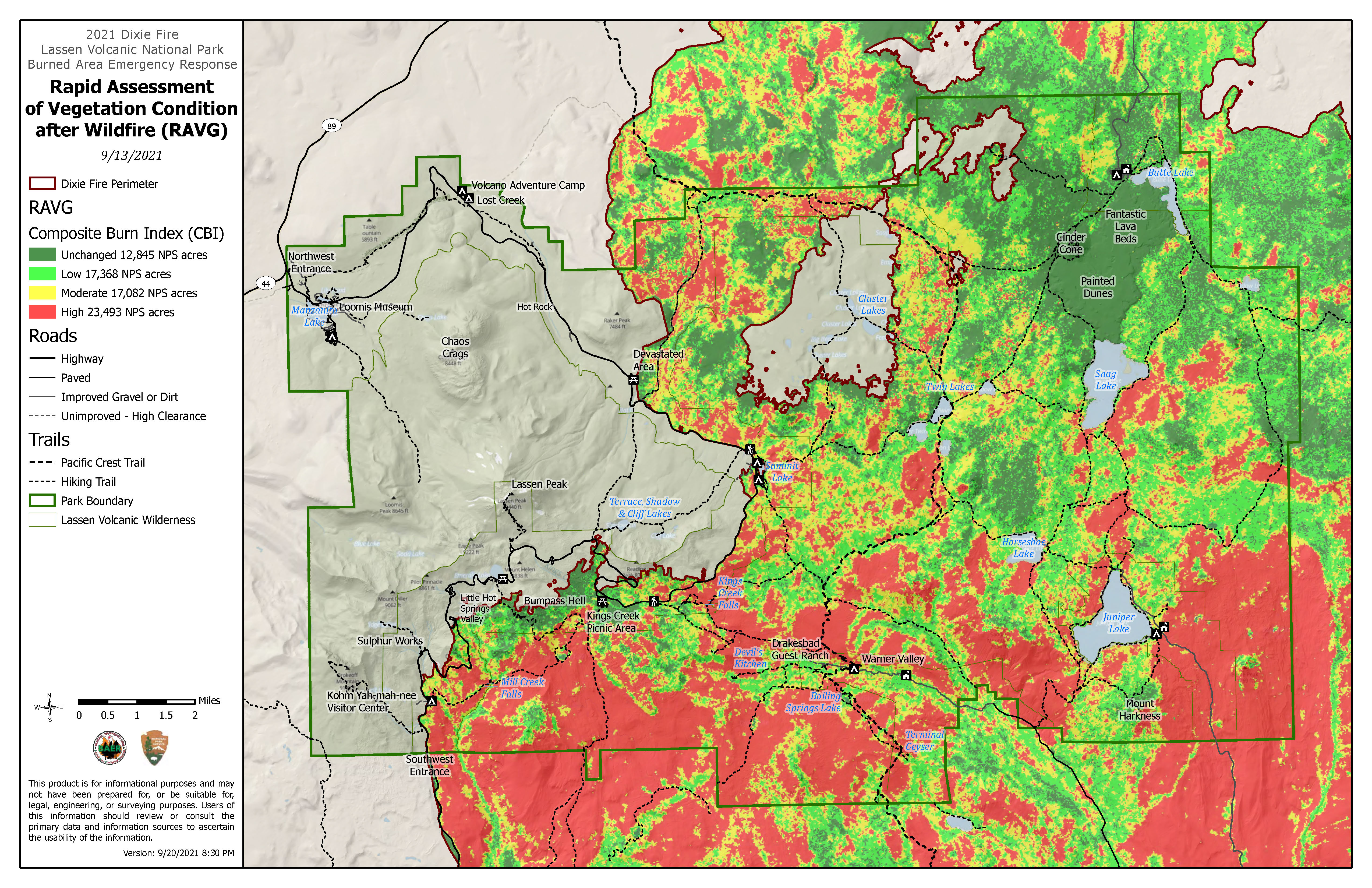
2021 Dixie Fire vegetation burn severity map
Safety:
Learn more about burned area safety.
Topography Maps (Available from USGS as Public Domain)
Manzanita Lake (northwest)
West Prospect Peak (center north)
Reading Peak (center south)
Lassen Peak (southwest)
Field Notes
Wildlife Viewing
- Black Bears
- Habitat: Black bears are common throughout the park, particularly in forested areas at lower to mid-elevations. They are often spotted around campsites, meadows, and near lakes and streams.
- Best Areas to See: Manzanita Lake, Summit Lake, Warner Valley.
- Mule Deer
- Habitat: Mule deer are frequently seen in meadows and forested areas at mid to lower elevations, particularly during early morning and dusk when they are most active.
- Best Areas to See: Bumpass Hell, Kings Creek Meadows, Warner Valley, and around lakes such as Butte Lake and Manzanita Lake.
- Mountain Lions (Cougars)
- Habitat: Solitary and elusive, mountain lions range throughout the park but are rarely seen. They prefer remote forested areas, often at higher elevations where deer populations are abundant.
- Best Areas to See: Seldom seen, but they range throughout the park.
- Sierra Nevada Red Fox
- Habitat: This endangered species is very elusive, typically found in high-elevation meadows, forests, and talus slopes. They are most active at night and are very rare to spot.
- Best Areas to See: Lassen Peak, the area around Lake Helen, and other high-elevation zones.
- Threatened Species: In 2021, the U.S. Fish and Wildlife Service listed the Sierra Nevada red fox, which includes the population found in Lassen Volcanic National Park, as a threatened species under the Endangered Species Act. This rare subspecies Sierra Nevada red fox (Vulpes vulpes necator), of red fox is native to the alpine and subalpine zones of the Sierra Nevada and southern Cascade mountain ranges, including Lassen. The listing aims to protect the species from further decline, as they are vulnerable due to their small population size, habitat fragmentation, and climate-related impacts on their high-elevation environment.
- Bats
- Habitat: Bats are common in the park and are often seen in forested areas, especially near water sources such as lakes and streams where insects are abundant.
- Best Areas to See: Manzanita Lake, Summit Lake, and Warner Valley in the evening.
- Bobcats
- Habitat: These elusive cats are found in a variety of habitats, including dense forests, meadows, and rocky areas. They hunt small mammals and birds and are more active at dusk and dawn.
- Best Areas to See: Lower elevation forested areas, especially near streams and meadows.
Reptiles/Amphibians
- Western Fence Lizard
- Habitat: These lizards are commonly found in rocky areas, open meadows, and forested habitats at lower and mid-elevations.
- Best Areas to See: Forested trails and sunny rocks near lakes and streams throughout the park.
- Sierra Nevada Yellow-Legged Frog
- Habitat: This rare amphibian species is found in alpine lakes and streams at high elevations. They are an endangered species, so sightings are rare.
- Best Areas to See: Lassen Peak region and other high-elevation lakes and ponds.
- Rubber Boa
- Habitat: These small, non-venomous snakes are typically found in moist forested areas, especially under logs and rocks.
Best Areas to See: Forested areas, particularly at mid-elevations.
Birding
Birdwatching at Manzanita Lake
Manzanita Lake is one of the most popular birding spots in the park. Its combination of water and surrounding forest creates a rich environment for waterfowl and songbirds. Common sightings include:
- Osprey
- Bald Eagles
- Canada Geese
- Various species of ducks like Mallards and Buffleheads.
Exploring Summit Lake
Summit Lake is another great spot, particularly for spotting birds around the marshy areas and mixed-conifer forests. Here, birders might encounter:
- Woodpeckers (including the Northern Flicker)
- Nuthatches
- Mountain Bluebirds
- Clark’s Nutcracker
- The surrounding trees are also home to a variety of small forest-dwelling species like chickadees and warblers.
Birding Hikes
- Brokeoff Mountain and Loomis Peak trails offer opportunities to see high-elevation species. On these hikes, you might come across:
- Gray-crowned Rosy-Finch
- Steller’s Jay
- Western Tanager
- Pine Siskin
- The changing elevation along these trails gives you a chance to see how bird species shift with altitude.
Wetland Birding at Warner Valley
- The Warner Valley area, with its wetlands and marshes, is an excellent spot for viewing water-loving birds like:
- American Dipper
- Yellow-headed Blackbird
- Red-winged Blackbird
- Birders can also find more elusive species such as the Wilson’s Snipe or the Virginia Rail in this area.
Spring and Fall Migration Watching
- During spring and fall, the park sees a variety of migratory birds passing through. Some of the notable species include:
- Swainson’s Thrush
- Warblers (Yellow-rumped Warbler, Hermit Warbler)
- Vireos and Flycatchers
- Lassen’s location makes it a good stopover point for many migratory birds heading north or south.
Ranger-Led Birding Walks
- Lassen Volcanic National Park often offers ranger-led birding walks during the summer months. These are educational outings designed to help visitors learn about local bird species, habitats, and birdwatching techniques.
Habitats in Lassen Volcanic National Park
- Forests: Lower to mid-elevations are covered in dense forests of lodgepole pine, red fir, and ponderosa pine. These areas provide habitats for black bears, mule deer, bobcats, and a variety of birds and reptiles.
- Meadows: Found at various elevations, these open grasslands are ideal habitats for mule deer, birds like the mountain bluebird, and small mammals. Kings Creek Meadows and Warner Valley are notable spots.
- Alpine Zones: High-elevation areas near Lassen Peak and Brokeoff Mountain offer unique habitats for species like the Sierra Nevada red fox, Clark’s nutcracker, and yellow-legged frogs.
- Lakes and Streams: Freshwater habitats like Manzanita Lake, Summit Lake, and Hat Creek provide a haven for fish, amphibians, and birds like ospreys and American dippers.
Outdoor Ethics and Safety
Leave No Trace: Always follow the park’s guidelines for responsible recreation, including packing out all trash.
Pet Friendly
Lassen Volcanic National Park is somewhat pet-friendly, but with notable restrictions. Pets are allowed in certain areas, but they are not permitted on most hiking trails, in the backcountry, or in park buildings. Here are the key areas where pets are allowed:
- Campgrounds: Pets are welcome in the park’s campgrounds as long as they are on a leash no longer than 6 feet.
- Parking areas, picnic areas, and along roads: Pets can be in developed areas, but they must always remain on a leash.
- Manzanita Lake: There’s a 1.5-mile Manzanita Lake Loop where pets are allowed, making it one of the few trails where you can walk with them.
If you decide to bring a pet, it’s important to follow the park’s guidelines to help protect the park’s wildlife and preserve the environment. Always clean up after your pet and ensure they don’t disturb the natural habitat. Pets have also brought up some big concerns over the past 20 years. One of the items cited in a request to name the Sierra Nevada red fox to the endangered species list was a case in which a dog killed a female fox in 2002. The incident occurred when the family dog became aggressive after the fox exhibited begging behavior.
The Sierra Nevada red fox (Vulpes vulpes necator), a rare subspecies of the red fox found in areas like Lassen Volcanic National Park, was listed as a threatened species under the Endangered Species Act (ESA) in August 2021.
Pet owners may face steep fines if a pet shows aggression or the actions of the dog lead to the death of a threatened species, namely the Sierra Nevada red fox. In addition to fines, having an aggressive event towards wildlife has detrimental effects on park management policies for other pet owners as well as the devastating results on endemic species of the national parks and forests.
Bucket List
Climb Lassen Peak
Drive and Explore the parks along the Volcanic Legacy Scenic Byway
Geology
Sites along the byway highlighting the volcanic activity of the region.
From volcanic peaks to lava beds, the drive along the fault scarp at Hat Creek Basin exhibits volcanic activity and is a viewpoint for both Mt. Shasta and Lassen Peak.
Cultural and Historic
Big Painted Cave and Symbol Bridge: These caves, part of the Lava Beds National Monument, feature Native American petroglyphs.
Scenic
McArthur-Burney Falls Memorial State Park.
- While not a lava bed itself, the park lies in a volcanic region, with the falls fed by underground springs coming from ancient volcanic rocks.
Stunning blue waters of Crater Lake of Crater Lake National Park.
Wildlife
The Lower Klamath (on the Volcanic Legacy Byway) is one of the two white pelican nesting colonies in California.
Gear-Up for Preparedness
Lassen Volcanic Legacy Locker via Rock Porch
- Sturdy hiking boots (for rocky terrain)
- Waterproof layers (weather can change quickly)
- Day pack with snacks, water, and maps
- Binoculars (for wildlife viewing)
- Camera
- Bug repellent: select Picaridin as the key ingredient (also repels ticks)
Gateway Communities
The gateway communities for Lassen Volcanic National Park are small towns and cities that provide services, accommodations, and access points for visitors to the park. Some of the main gateway communities include:
- Redding, California: About 50 miles west of the park, Redding is the largest city near Lassen. It serves as a major hub for lodging, dining, and supplies for park visitors.
- Chester, California: Located around 30 miles from the park’s southwest entrance, Chester is a small town on the northwestern shore of Lake Almanor. It offers a closer option for lodging and amenities.
- Mineral, California: A small town only about 10 miles from the southwest entrance, Mineral provides quick access to the park and offers accommodations, including a few motels and campgrounds.
- Old Station, California: Located near the northern entrance, Old Station is a small community along Highway 44/89, providing access to the northern part of the park. It has a few services, including RV parks and campgrounds.
- Susanville, California: About 45 miles east of the park, Susanville is another larger town with more amenities, including restaurants, hotels, and grocery stores.
These communities provide a convenient base for exploring Lassen Volcanic National Park, with varying options depending on which park entrance you plan to use and what time of the year, your Lassen Volcanic adventure will take place.
In the Neighborhood (or close enough)
Cities and Towns to include when making doing a day-trip Itinerary from Lassen Volcanic National Park
Travel time: Approximately 3 to 3.5 hours
Ferndale, California:
Distance: About 160 miles (257 km)
Travel time: Approximately 3.5 to 4 hours
Reno, Nevada:
Distance: About 130 miles (209 km)
Travel time: Approximately 2.5 to 3 hours
Sacramento, California:
Distance: About 150 miles (241 km)
National Park and State Park add-ons for enhancing a road trip when visiting Lassen Volcanic National Park are a good way to see more parks per visit.
I used Sacramento as a “basecamp” in December, 2021 and visited both Lassen Volcanic National Park and Pinnacles National Park as Day-trip itineraries while staying 3 nights at the Citizen Hotel in the Capital City of California.
In 2014, I visited the Northern California area and made Lassen Volcanic National Park a stop on a road trip which started in San Francisco and ended in Las Vegas. The Lassen Volcanic (section of the trip) started in Ferndale, California after a visit to Redwoods National and State Parks en route to Yosemite via Tioga Pass near Mono Lake. We stayed the first night of this travel leg in the colorful town of Ferndale, California at the Gingerbread Mansion then ended the day for a well needed respite (following the Lassen Volcanic Scenic Drive) at a ski lodge in Mammoth Lakes. The following morning, we traveled to Mono Lake before crossing over Tioga pass into Yosemite valley of the famed Yosemite National Park. This road trip itinerary was timed for travel during the last weekend of May and I was constantly refreshing my Caltrans page to see if the high mountain pass roads were open (I had made many of the bookings as much as 6 months before the trip).
-
Where is Lassen Volcanic National Park located?
-
Lassen Volcanic National Park is located in northern California, about 50 miles east of Redding. The nearest towns are Mineral and Chester.
-
When is the best time to visit Lassen Volcanic National Park?
-
The best time to visit is during the summer and early fall (June to October). Snow often lingers into June, and the main park road typically opens by mid-June. Fall offers fewer crowds and crisp, cool weather. Winters are long and harsh, but ideal for snowshoeing and cross-country skiing.
-
What are the must-see attractions in Lassen Volcanic National Park?
-
- Some of the park’s must-see attractions include:
- Lassen Peak: The iconic volcano with a challenging summit trail.
- Bumpass Hell: The largest hydrothermal area in the park, with boiling springs and steam vents.
- Cinder Cone: A steep hike to the top of a cinder cone with panoramic views.
- Sulphur Works: Easily accessible geothermal activity right off the park road.
- Manzanita Lake: A peaceful lake with stunning reflections of Lassen Peak.
- Some of the park’s must-see attractions include:


